MapCreating

Frequently asked questions

Here you will find questions and answers concerning all areas related to the functioning of MapCreating. We encourage you to ask further questions if something is still not clear.
1. Why do the contour lines not have described values?

NASA and Copernicus digital terrain models were used to generate the contour lines. Their vertical accuracy in the forest, urbanised, or high mountain areas are too low to correctly describe the contour lines. Therefore, their role is to present the terrain shape, the values of the elevation points are used to read the height.

2. At what zoom should I view a map in Adobe AcrobatReader®?

To verify the correctness of the mapping of individual content elements, it is worth using a zoom of up to 500%. But to assess the entire thing, we recommend the natural size, i.e. 100%.

3. Will I get a discount when buying a larger number of maps?

Yes, if you buy two maps, the third one – no bigger than the previous ones – will cost €1. If you are a company and are planning permanent cooperation, we can sign a contract including additional discounts.

4. What discount will I get with permanent cooperation?

This depends on several criteria, such as map format, the region of the world to which the maps refer, and the extent of the required licence. The multitude of factors prevents us from determining sample prices in advance; they depend on specific factors.

5. Why does it take longer to generate configured maps than it does with your competition?

After you accept the map template, the program initiates performing classic cartographic activities, but in a modern form. Therefore, the data is not only downloaded from the database but also assigned complex graphic attributes. The content is also subject to highly complex processes of qualitative and quantitative generalisation, which requires most work but also determines the high quality of our maps to the largest extent. The high final resolution of maps also has an impact on the implementation time.

6. Why don't I get the map right after I pay?

Our mapping portal is not just a shop but a factory; the map must be produced first. If you order furniture, a car, or clothing tailored to your needs, you also have to wait. That is why we ask for your understanding and patience.

7. What is the optimal resolution?

It depends on the purpose of the map. For displaying in the Web, the best is 180 dpi, 150 dpi is enough to print a billboard, and 300-400 dpi is usually required for plotter printing of a wall map. The most demanding is the offset printing of handheld maps and book maps – here, 600 dpi is required; do not listen when someone recommends a resolution of 300 dpi like for a typical photo. 600 dpi ensures that the map is printable.

8. Does the price depend on the resolution?

No. However, remember that a higher resolution means a significantly longer time generating the final map during the final phase. Therefore, choosing the optimal resolution become worthwhile.

9. Do colours have overprints?

Yes, in vector format, useful for maps with a small amount of content, and in raster pdf/ tiff format exported in special quality mode. They are not included in maps in the standard raster format.

10. Can maps be generated in other projections?

Unfortunately, that’s not possible. However, we ensured the correctness of choosing cartographic projections in terms of the scale, the presented area, and the extent of the map.

11. Can I choose any scale?

You can choose from 125 scales, although some scales are currently unavailable for geodetic purposes. We make sure that the scale is round so that you can easily calculate distances on the map. Scales are available for all popular series of topographic maps in the world.

12. Which scale is bigger and which is smaller?

You can look at a scale as a fraction – 1:100 is the same as 1/100; the greater the denominator value, the smaller the fraction or scale. Mapmakers argue that the smaller a house drawing is on the map, the smaller is the scale of the map.

13. Can I return a map I purchased?

Your map is a highly customised product and generated specifically for you; therefore, it is not possible to return a digital or paper map or receive the money back. That is why we kindly ask you to carefully look at the map’s draft image before purchasing, preferably with a magnifying glass.

14. Damage to the paper map.

If you determine physical damage to a paper map that occurred before the map arrived to you, please return it at our expense, and you will receive a reprint free of charge.

15. How often is the database updated?

The OpenStreetMap® database, which constitutes the basis for creating maps at large scales, is downloaded from the OSM server once a month. The source database for medium-scale maps is updated quarterly. The source database for small-scale maps is updated as needed.

16. Why do I not see changes on the map right away during personalisation?

In most cases, each of your decisions has serious consequences for the map’s structure and is potentially associated with the need to wait a long time to refresh the map’s content – you would certainly not want to wait that long. That is why we’ve decided to collect all the modifications together and only then generate a new draft image.

17. How to make a custom map?

First of all, each of your maps is inherently unique, the only one in the world. But the most profound customisation options are provided by the advanced Content/ Base content elements tab, where it is possible to enable/ disable the visibility for each of the 92 groups of map elements. Create map online

18. How to make a digital map?

MapCreating will generate a ready-made map for you. You are asked only to personalise its content; you can also manually add a number of your own information at the end.


Comment faire une carte? – MapCreating générera une carte prête pour vous. Il vous est uniquement demandé de personnaliser son contenu, vous pouvez également ajouter manuellement un certain nombre de vos propres informations à la fin.


Come fare una mappa? – MapCreating genererà una mappa pronta per te. Ti viene solo chiesto di personalizzarne il contenuto, puoi anche aggiungere manualmente una serie di tue informazioni alla fine.


Harita nasıl yapılır? – MapCreating sizin için hazır bir harita oluşturacaktır. Sizden yalnızca içeriğini kişiselleştirmeniz istenir, ayrıca sonuna kadar kendi bilgilerinizi manuel olarak da ekleyebilirsiniz.


Como fazer um mapa? – MapCreating irá gerar um mapa pronto para você. Você só é solicitado a personalizar seu conteúdo, você também pode adicionar manualmente um número de suas próprias informações ao final.


Como hacer un mapa? – MapCreating generará un mapa listo para usted. Solo se le pide que personalice su contenido, también puede agregar manualmente un número de su propia información al final.

19. How to make a road map?

During the Theme customisation stage, select Administrative and Road map. In the advanced Base content elements tab, disable the groups of content elements that, in your opinion, are unnecessary. Done, you can generate a map.

20. How to create a map of the world's countries?

When determining a region, at the end of the scale list, select Continents or the World – as a whole, type World and select it from the list. After determining the size or scale, choose the Administrative map as the Theme. In the Layout tab, determine the language and alphabet of the map’s nomenclature. That’s all. However, you can always adjust the visibility of item groups in the advanced Base content elements tab.

21. How to make personalised map?

Our portal suggests default settings, so you don’t have to change a thing. However, making any modifications will result in the map being personalised and a custom map will be created.

22. How to make your own map?

The more default options you change, the more your map will be yours and yours alone. MapCreating allows you to create a professional map, adjusted to your needs, as a real online map editor.

23. How to build a map?

Click the Create Maps button, and MapCreating will do all the work. At the beginning of the customisation process, take a moment to specify the geographic extent of the map and the paper size. The system still offers further options; if you change something, look at the changed map example, whether this form of the map suits you. After finishing the customisation, press the Generate Map button. A draft image will be created. After assessing it, you can go back to the first step of personalisation in order to implement corrections, add your content manually, or proceed to purchase. After performing the payment, the map will be generated in the final form.

24. Why do I need to verify the draft image of the map – I assume you make good maps.

We created the world’s first so complex process for make maps, but we can’t control everything. And we can’t see your map, so we can’t guarantee it’s perfect. Each user has a different point of view; the map may contain faults unacceptable to you.

25. Can I create an atlas with the maps?

Yes, it can be an overview atlas. With MapCreating, you can generate pages of the same size, scale, or multiplicity using the same template stored in your account. You will receive very uniform work, covering any area in the world. If necessary, contact us to receive a discount on maps.

26. Is there data for my region?

You can easily check it on the OpenStreetMap website. If you see a lot of information for your area, it will also appear on your map. In small scales, the data is always.

27. Why can there be only five maps in the cart?

Generating each map puts a strain on the server, while it is always a multi-generation. A large number of maps created and not purchased results in the costs of maintaining the server used to generate them are not covered by the sales revenues. That is why it is necessary to limit the possibility of creating out draft images.

28. Do you offer vector pdf files with editable layers?

Our maps are very complex from technical point of view and can be saved in an encapsulated format only. This is a vector map, not editable, without layers.

29. How often and for how long can I download the final map from my account?

ou can download the map as many times as you want for 90 days. After that time, the map is removed from your account due to its content becoming obsolete. You will receive a 66% discount on the new map.

30. Can every map be printed?

A map for printing must have a proper resolution, e.g. 300 dpi or 600 dpi for offset printing. CMYK colour model. Only 600 dpi files constitute maps in high resolution.

31. How to make informative, user-friendly maps?

These are maps that include only what you need and nothing else. A classic map includes a lot of information unnecessary for you; you need to delete it in advance. Select the appropriate theme – step 2 Content/ Theme, in terms of Density select a low density of content, and then in the advanced Base content elements tab, disable the visibility of unnecessary groups of content elements. Alternatively, enable what’s missing. Done. You can now generate the map.

32. Are maps for humanitarian operations different from others?

They include a watermark; such maps cannot be shared commercially; they are intended to help in rescue missions. You determine the scope of content – rivers and lakes, roads and railways, locations, and hill shading are all definitely significant. If the background is poor, it is worth adding a satellite or landscape image. We would remove the contour lines, perhaps forests and other vegetation coverage.

33. Does the licence allow to post the map online

Yes, such an option is provided by the No-limit licence.

34. Why do prices vary so much for different classes of territory?

The density of content and the cost of obtaining, preparing, and transferring it are quite different.

35. Why do you believe your map is better than the one made in GIS?

GIS software focus on obtaining and processing spatial data. They include visualisation functions but offer automatic solutions considering some principles of cartographic correctness only; better results can be achieved only through lengthy and burdensome work. In the case of the cartography software, being the core of the process, everything is optimised in terms of producing a great, informative, and user-friendly map.

36. Can I use a free map without restrictions?

Yes, just don’t remove the publishing imprint.

37. Are there plans for any other language versions?

There are many aspects of using different languages in the process and on maps. With small scales, we want to develop various language versions: German, French, Spanish, and then the following versions. There are already ten languages to choose from in the legend, will ne next. The process website will be prepared in German, and then the following ones should appear. It all depends on the demand from users.

38. Will names on the maps also be available in other alphabets than currently available ones?

We plan to maintain the availability in Latin and Cyrillic alphabets; perhaps Greek will also be available. Due to, among others, the complexity of the transfer of names in other alphabets, we cannot be sure that the result will be satisfactory for them.

For political reasons, the course of disputed borders, with an undetermined course, as well as the status of dependent territories, has been adapted to the guidelines of the Polish Ministry of Foreign Affairs – the borders are in line with their official status in Poland.

40. Will the map generation process be halted when I leave your website?

Nie, proces będzie trwał dalej. Mailem dostaniesz informację o jego ukończeniu.

41. Can you correct a map I have already generated?

It is difficult, but not impossible. First, we can verify whether it is possible to improve the process so that the error disappears during the following generation process. The second solution consists of manual work on an intermediate file, available to us only; the cost is €100/ h.

42. Why are there symbols in the legend that aren't on the map?

At this time, we are unable to determine what the fundamental features on the map are within the geographical extent selected by you. Hence, for example, tundra may appear in the legend of a map of Africa, and there will be a rainforest for Canada. The symbols in the legend correspond to the map theme you selected, possibly modified by enabling/ disabling the visibility of content item groups.

43. Why doesn't the legend include a description for all the symbols I see on my map?

The most common cause is the lack of space in the legend, the process selects symbols according to a specific hierarchy. It may also happen, although it is rare, that we did not expect a specific object to appear in the content of the map and that is why we did not include it.

44. Can I share a private template with others?

This template belongs solely to you only; for procedure-related reasons, it cannot be sent to other accounts.

45. Can I use the template to create a different map on any scale?

The template matches a group of scales similar to the one designed by you. Deviating too much from the map scale values will result in the template resetting to the default values. Scale groups are described here.

46. Can I close the browser while generating the map?

Yes, the process will run in the background without stopping. When generating a draft image, it is worth checking the user account after some time and checking whether the map has already been created. In the case of the final version, which takes longer to be created, you will receive an e-mail when the generating is finished.

47. Why all content categories selected in the Basic content elements tab are not always visible?

This happens, for example, when you select larger than standard symbols in the last tab, i.e. Symbol size. 
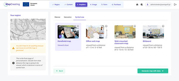
There would be too much information on the map and the process excludes a part of the content category from inclusion, very small part.

48. Why I don't see hill shading or landscapes

We are constantly working on making them available as soon as possible. You can use them now in small scales for maps of continents and whole the World.

You didn't find the answer to your question. Let us know.

Please describe your issue as comprehensively as possible so that our answer can be more accurate. We kindly ask for your question to be in English; we can also work with Polish 🙂